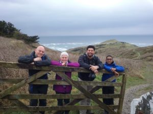
As anyone who has read any of my reviews in the past will know, my son and I are attempting to walk the whole 600+ miles of the South West Coastal Path. Sometimes we have been joined by other family members, sometimes it is just the two of us. In April this year we resumed our walk. After what has seemed like a very long winter it was a little like coming out of hibernation! Packing my walking boots and rain wear and anticipating those beautiful Cornish coastlines made me feel quite excited and exhilarated. This trip was a family affair, myself, my son, his partner Pauline, my 28 year old grandson Deion and my 12 year old grandson Andre. The only person missing was my middle grandson, 25 year old Jordan who was too busy studying for his Masters Degree to join us.
We drove down to Cornwall and stayed in a lovely cottage at Coldharbour Farm in Bodmin. (See separate review). We arrived in the rain and the next morning it was still overcast. It looked like that rain wear was going to come in useful! Pauline isn’t a keen walker but she drove us to Tintagel which is where we ended the last segment of our walk last October and she joined us for about a mile before heading back to the village.
The 4 of us walked up to Glebe Cliff and followed the route close to the cliffs edge. We passed a medieval church and between Tregalla and Trebarwith we passed what used to be quarries called Baglow and Lanterdan. Lanterdan has a distinctive stone pillar. It seems they quarried here from medieval times to the 1930’s. The first part of the walk was relatively easy (albeit very muddy) and amazingly the sun had come out. It then became very steep with lots of ups and downs. The scenery was, as usual, stunning with huge waves crashing against the rocks below. In the Guide Books it says it is dangerous to swim here. Personally, I cannot see why anyone would be foolhardy enough to try!
After a few steep valleys we came into Trebarwith Strand There was a pub, The Prince William and a few houses and shops. We zigzagged up the next hill rising from sea level to 90 metres and then dropping down again at Backways Cove. After Backways Valley (which was very peaceful with a stream and foot bridge) we climbed up to Treligga Cliff. There are seven steep descents along this route and because it was so muddy we were much slower than anticipated and began to realise we were not going to make our rendezvous with Pauline.
We then passed Tegardock Valley and ‘The Mountain’, a steep little peak isolated by erosion all around it. There were sheep and lambs in the fields and we even saw a baby lamb that had obviously just been born. It was adorable! We also saw a number of hawks soaring above us. As we passed Jacket Point we decided to head inland and meet Pauline at a new destination. We arranged to meet at a deserted farm building called Dannonchapel. Crossing through cow fields the mud was ankle deep (well we were hoping it was just mud!) It was a relief to get to the road and see Pauline waiting for us.
The next day Pauline drove us back to Dannonchapel and again we had to pass through ankle deep muddy cow fields. The cows all had calves and we had been told to keep our distance as they might be a bit protective but we managed to navigate past them without incident!
Rejoining the Coastal Path we completed the 3 steep valleys we hadn’t managed yesterday. The last valley NW of Lower Hendra was the steepest and most slippery. It was incredibly muddy and all of us slipped on the mud at one point (causing a little light relief en route!). We passed St Illickswell Gug and Rams Hole before descending into Port Gaverne which was a former slate port and fishing village. We watched some people jumping off rocks into the bay below. Coasteering is popular along that coast.
We met up with Pauline and walked the last quarter mile into Port Isaac. Port Isaac is where Doc Marten is filmed. It reminds me a little of a smaller Clovelley, it has shops, pubs and restaurants and the road slopes down to the harbour. The weather had been lovely so we bought a Cornish Pasty (what else!) and sat enjoying the sunshine in the harbour.
The next day we took a break from walking and spent the day at The Lost Gardens of Heligan (see separate review).
The following day Pauline decided to join us on the walk so we drove to Port Isaac, left the car there and the five of us headed off. It was a fairly easy walk, mainly gentle sloping paths. As we rounded Kellan Head we saw the natural harbour of Portquin. Supposedly this was a prosperous fishing community until most of it’s fisherman were lost at sea. Their widows all moved to Port Isaac making it almost a ghost town.
On the headland to the West of Portquin stands Doyden Castle. This is a folly that is now a National Trust holiday home (with a 2 year waiting list I believe) but it was originally built by Samuel Symmonds when he bought the headland ( who buys a headland?) in 1827. He used it as a place where he and his friends could go to drink and gamble. Just behind it is Doyden House (built by an ex governor of Wandsworth Prison as his retirement home!)
We passed over slate stiles and passed cordoned off mine shafts. Our end destination today was Lundy Beach where we saw Lundy Hole. This was once a cave but the roof collapsed leaving only the entrance arch majestically still standing.
We walked up to the car park and rang for a cab to take us back to Port Isaac. I had found a phone number for a shuttle service the previous day (Marco 07866223786) and when he picked us up we had the most hilarious ride back to Port Isaac. Marco is like a hyperactive Robin Williams and he made us laugh all the way back to the car park in Port Isaac. (If you are in the area and want a cab, call him, you will get a cabaret thrown in as well!)
The next day was our final walking day and it was just my son and I. Deion had to catch a Megabus home that morning due to work commitments and Pauline and Andre decided to spend a day together.
Pauline drove us to Lundy Beach and we started off again. I have to say this walk from Lundy Beach to Padstow was one of the most pleasurable parts of the Coastal Path so far. Gentle rolling hills, wonderful views and the weather was perfect. After about an hours walking we came to an outcrop called The Rump. We walked round this and to our sheer delight we finally saw seals playing in the surf below us! During the 143 miles of the Coastal Path that we have walked so far we had not seen one seal! Now, we had 4 or 5 of them playing amongst the crashing waves! It was my highlight so far!
There is a lot of pillow lava along this stretch. This was forced up through the sea floor when this area was formed. It is an impressive sight. We carried on to Pentire Point where we had a lovely view of Padstow Bay. In the distance we could see the lighthouse at Trevose Head. We then turned SE to Polzeath. We walked down the cliff side, which was covered with bright cheery yellow gorse and into Polzeath. We met up with Pauline and Andre for an ice cream and sat on the beautifully white sandy beach watching the surfers for a while. Then we set off for the last 3 miles of our walk. Again it was a beautiful walk through sand dunes and alongside the sea. We came into Daymer Bay which was a much quieter bay (no surfers here, just a couple of paddle boarders). The path took us through the dunes again, past a golf course and then past a totally deserted stretch of white sands by Brea Hill. This led us into a place called Rock where we met Pauline and Andre again.
We wanted to finish this leg of the walk in Padstow so we all caught the Black Tor Ferry and spent a little time there before returning to our car and heading back to Bodmin. Padstow is quite a busy little touristy fishing village with lots of shops and pubs.
So now we have completed the stretch of the South West Coastal Path from Tntagel to Padstow. We did about 21 miles this week (making our total so far about 164 miles) – only about another 400+ to go!


