We are back in Cornwall! As you may have seen in my previous reviews, my family are trying to walk the whole of the South West Coastal Path (in stages) and this June we headed back down to Cornwall for our 9th visit. Our group consisted of myself and my son, Scott and my 26 year old grandson Jordan. We had booked accommodation at Tolroy Manor which is one of the John Fowler Holiday Parks. It was a special offer from The Daily Mail newspaper (£60 for a 3 bed roomed house for 3 nights) and it was situated in Hayle, which was very convenient as it was the last point we walked to on visit 8. The house was pretty basic but fine for our short stay.
HAYLE TO ST IVES (6.5 MILES)
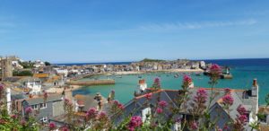
We had driven down so we checked in, dumped our bags and headed straight off on our walk. It was a beautiful evening and we were planning on walking the 6.5 miles into St Ives. We headed off through the town (Hayle was once a really important supplier of machinery and materials for the Cornish mines. Brunel and Trevithick were closely connected to the town in the past).
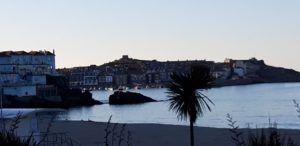
We started off at the oldest swing bridge and walked along the estuary. Over 270 species of birds have been recorded on these mud flats (we didn’t see quite that many!) Then we crossed under the viaduct and along St Michael’s Way (this is a 12 mile footpath that you can follow all the way to St Michael’s Mount). This road is also linked to the pilgrims route that led from Lelant to Marazion and onwards to the Santiago de Compestela in North West Spain. We passed St Uny’s Church in Lelant with it’s ancient Cornish crosses, crossed a golf course (keeping our heads down!) then under the railway bridge and along the dunes behind Porth Kidney Sands. As usual the coastline was stunning and just when you thought the views couldn’t get any better we came out above Carbis Bay which is slightly more commercialised with a nice spa hotel and beachfront restauranT but is still gorgeous. Leaving the beach we entered the wooded outskirts of St Ives and then arrived in the town. We just had time for a bag of delicious chips before we caught the train back to Hayle.
ST. IVES – ZENNOR (6.5 MILES)
The next morning we headed off in the car and parked up at a little place called Zennor. We then got the bus back to St Ives and began our walk (at this point a word of caution, if you ever do any of these walks, check the bus timetables carefully. Sometimes there is only one bus an hour and you need to try and tie up times so that you don’t waste time sitting at country bus stops). St Ives is lovely with lots of art galleries and the Tate Gallery which is very popular. It is however commercialised and very crowded but we enjoyed our walk through the town. It was a fairly gentle stroll with lovely views but once we had passed Clodgy Point it turned into a strenuous journey of roller coaster climbs. This is classed as one of the most difficult sections of the Path and we truly felt it! From Clodgy Point all the way to Cape Cornwall is a “site of special scientific interest”. It is boggy at times but there were often stepping stones for us to use. At one point we were literally clambering over boulders, this is not a stretch for people with walking problems! This was a 6.5 mile walk which felt like 10 miles! We were all pleased to arrive at Zennor and we thought we deserved a drink in The Tinners Arms before getting into our car. (Zennor also has an interesting graveyard and there is supposed to be a bench with a mermaid on it but we failed to find this!)
ZENNOR – PENDEEN (7 MILES)
The next day we drove back to Zennor and parked then started our walk from there. The weather was a little showery but the walk was easier and there were no boulders to traverse on this stretch. However the stepping stones we had to use were wet and slippery so our progress was quite slow. We passed Mussel Point where you can often see seals (we didn’t) and we passed Wicca Pool with it’s rugged cliffs and giant fingers of granite. There was the remnants of an ancient settlement and cliff castle at Gurnards Head and we saw the ramains of Bosigran Castle, an iron age fort. Before we reached Pendeen we passed the most idyllic little bay, Portheras Cove. Although the cove looks very inviting there were signs advising us not to swim here or walk barefoot on the sand as there are still metal fragments from the dynamited wreck The Alacrity which ran aground in 1963. As Pendeen Lighthouse came into view we passed ponies in a nearby field and the rain was really falling now. We had to walk into the village to catch the bus back to Zennor and by the time we arrived there we were soaked. We decided to take shelter in The Tinners Arms again and we sat by the roaring fire to dry off and had a superb roast dinner (and luckily for me they did a veggie one as well!).
PENDEEN – BOTALLACK (2 MILES)
The next day Jordan was leaving us as he had to get back to an event he was organising in London so we dropped him off at the station and we drove back to Pendeen. We were only going to walk a few miles before heading home and the weather was lovely, It was an interesting stretch as there were a lot of mine shafts and chimneys and had we had the time we might have taken a tour of Geever Tin Mine Heritage Centre. The walk was mainly along the cliff top with the usual stunning views and we walked to Botallack and then got the bus back to pick up the car in Pendeen and head back to London.
So we did another 22 miles of the Path and we have now done 244 miles in total. Only 386 miles to go!


