We are back on the South West Coast Path! Visit 20! Just myself and my son,. Scott, this time. We took his car and drove to Exeter where we had found very reasonably priced accommodation for 3 nights. It was called Magdalen Quarters and was a tiny little house but had everything we needed. It had the largest TV I have ever seen, it literally almost took up one wall of the living room. In fact, the whole house looked like it had been designed as a man cave. There was a games console and numerous games, all the lights and lamps seemed to be designed out of plumbing parts and all the cushions, carpets and even the coasters had a distressed design which is definitely more manly than female. It was rather unusual but I would highly recommend it.
Prior to going to our accommodation we decided to do a little walking. We had finished our last walk at Ladram Bay which is just 2.5 miles outside Sidmouth and we thought we would walk those short miles before getting into the serious walking the next day.
LADRAM BAY – SIDMOUTH 2.5 miles
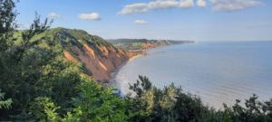
We parked in Sidmouth and got the 157 bus to Otterton Village and then walked to Ladram Bay. It was a lovely hot day and as we started the quite steep climb to the holiday park, the views of the red sandstone stacks were stunning! The colours of the cliffs and the colour of the sea reminded me of those old vintage railway posters that are once again popular, all orange and blue shades. The climb took us up to High Peak (the site of an iron age settlement) and we were walking through what looked like a Christmas tree forest. As we headed down towards Sidmouth we saw the Iron Age Fort of High Peak. We followed the track to Peak Hill and then we were heading down into Sidmouth itself. We passed the bay called Jacob’s Ladder where there is a park and an intriguing Second World War pill box. As we walked through Sidmouth I thought it looked a little more up market than other sea side towns we have encountered. With it’s striking Regency architecture it still had a grand look about it. So we started Visit 20 with a short 2.5 walk but it was, nonetheless, quite a pretty one.
SIDMOUTH – SEATON 10.3 miles
This morning we left our “man cave” and headed to Seaton where we found somewhere to park. We then got the 9A bus back to Sidmouth. The guide book had told us that today would be a “challenging walk” and to start off with it definitely was! We left the red cliffs of Sidmouth and set off along this rugged section of the Jurassic Coast World Heritage Site. Supposedly we were crossing 200 million year old rocks! We had crossed the River Sid on the ornate Alma footbridge at the Eastern end of the beach and climbed the cliffs to Salcombe Hill. The view from the top was incredible. Down in the next valley was Salcombe Mouth, a shingle beach secluded and only accessible by a steep path. We crossed the stream by the footbridge and climbed Dunscombe Cliff. We went through a kissing gate (there is a lot of them on this stretch) and the walking levelled out for the next few fields. The path meanders after that through many old lime pits before coming close to the edge of Lower Dunscombe Cliff. We followed a zigzag path through Dunscombe Coppice and the meadow below then connects the cliff top and Weston Mouth. Weston Combe is a valley of hedgerows, small fields and wild flowers (and an awful lot of butterflies!) We went right down to the shingle beach but disappointingly our walk on the beach was very short before we started heading up again! After that it was a series of open fields and overgrown woodland areas. The next place we passed was Branscombe Mouth which looked like a lovely little place. We had an ice cream stop here. Once a busy area for smuggling, this area has been more recently known for the stricken MSC Napoli. From here, our next stop was Beer (the village not a pint!). To get there we had two choices. The official route down into the Under Hooken or keep to the cliff top. Wanting to keep it official we chose the Under Hoken route and I am so glad we did. In the shadows of the Hooken Rocks we had a walk with fabulous views which hugged the cliff side. There were a few steep ascents but once done (when you stop sweating and your heart stops galloping) they are soon forgotten and the incredible views of a sparkling sea and beautiful coast line make them worthwhile. We arrived in Beer, which I didn’t think was as pretty as some of the other places we had passed, but it does have history. It was the birthplace of the notorious smuggler Jack Rattenbury also known as “The Rob Roy of the West”. This little fishing village is protected from winds by the enormous chalk cliffs which have been quarried for centuries and as it is very easy to carve has been used and can be seem in Westminster Abbey, St Pauls and Exeter Cathedral. Leaving Beer we had to detour a bit as in 2012 land slips destroyed the coast road east. We could have crossed the beach but it is dangerous at high tide so we had to leave Seaton Hole and follow the diversion signs into Seaton. A long hard 10.3 miles and we were happy to find a nearby pub that we could enjoy a meal and nice cold drink at. (The Eyre Court Hotel in Seaton is worth a visit as they have a good menu).
SEATON – LYME REGIS 7.5 miles
Happy Birthday to me! Yes it was my birthday today so after Scott greeting me with Stevie Wonder’s “Happy Birthday” song playing from his phone and me opening my cards, we headed off and left the car today in Lyme Regis. Catching the (now familiar) number 9A bus back to Seaton we resumed our walking. (No day off for the birthday girl I am afraid!) Today was supposed to be a “moderate walk”. I am not sure about that! It was certainly a different kind of walk. We started off walking around Seaton Harbour and followed the signs up to a golf course. In the guide book and enroute were warnings that if you started this 7 mile walk there was no way to stop half way through. There were no car parks or coves along the route so you had to do the full 7 miles or do a little then turn round and return to Seaton. We had left Seaton via the very old original Axe Bridge (the oldest serving concrete bridge, built in 1877) and passed the Axe Bridge Golf Club when we entered the Undercliff National Nature Reserve. Now I hadn’t planned to spend my 72nd birthday doing a rerun of Scott and I’s Black Forest walk (see a review some time ago!) but that is what it felt like today! The woods that we walked through for the whole 7 miles were almost jungle like! (Think Jurassic Park, Gorilla’s in the Mist or Lord of the Rings – whatever film genre you prefer, these woods resembled them!) Every now and then there was a gap in the tree’s allowing us to see the cliffs on one side and the sea on the other but for the most part it was a shady dark forest! Deers, badgers and foxes live here but we saw none of them (the best we saw was a little shrew). We walked over Goat Island (which isn’t actually an island). It is caused by previous dramatic land movements and is now a plateau with a 3/4 mile chasm. Most of the trees were ash, hazel, beech, holm oak and sycamore. We walked up dales, down dells and climbed fallen tree trunks enroute. The path was very easy to follow (no one could get lost on this stretch) but it was covered with tree roots whose sole purpose seemed to be to trip us up! It was quite arduous and I became bored by the same scenery all the time. (Part of the joy of the South West Coast Path is the different vista’s you encounter, beautiful cliff top views followed by a small woodland walk then more sea views, it is what makes it so wonderful!). This was tree after tree after tree for 7 miles! We had a small detour to look at an old sheep wash. Finally we arrived at a kissing gate which marks the borders of Devon and Dorset. We are now in the last county of our walk! Quite an achievement I felt. Once away from the woodland we walked down some fields into The Cobb (the ancient harbour) at Lyme Regis. This town was mentioned in Persuasion by Jane Austen and it was once a prosperous outlet for the wool trade. Although the harbour attracts little commercial trade these days it still helps to protect Lyme from erosion and provide a safe haven for fishing and sailing boats. It was another hot day (not that we saw the sun much in the woodland!) so I then had a real birthday treat. Scott bought be a bag of chips which we ate on the beach! There is nothing like seaside chips! Absolutely yummy!
LYME REGIS – CHARMOUTH 2.5 miles
We were leaving our accommodation today but after we had packed the car and shut the door on our “man cave”, we decided to do a little more walking before heading back to London. We drove to Charmouth and got the X51 bus back to Lyme Regis. As we started walking from Lyme Regis we had to follow detours as the cliff top path has been closed for some years due to coastal land slips. The detour route went through a few woods but was mainly road walking so not as interesting as other walks. It was only 2.5 miles so we arrived back in Charmouth quite quickly. This is a sweet little seaside resort with the very impressive Charmouth Heritage Coast Centre which is housed in an old cement works. You can find fossils on Charmouth beach but our quick scan of the area didn’t discover any finds! The beach is shadowed by the Golden Cap (the highest point on the South Coast of England at 191 metres!) That is where we will be heading on visit number 21!
So we have now done 550 miles of the Path, just 80 miles to go!


